
Forthcoming field campaigns
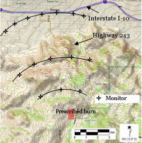
Poppet Flats 2007
|
|
|
|
Measurements of the flow and turbulence perturbations caused by the fire. Actual slope profile is presented (vertical scale is exaggerated). Average slope angle is 7.6 deg. |
|
|
|
|
|
Proposed deployment of air quality (gas and particulates) monitors in the Poppet Flats area. Monitors will be placed at approximately 2.5, 5 and 10 kilometers from the burning area. |
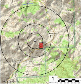
Schematic of eventual LIDAR deployment for fire plume tracking. Rectangle presents potential prescribed fire area. The white star marks the LIDAR location and concentric circles represent scanning ranges of 1, 1.5 and 3 kilometers. |